GMW Launches GAUSS-Aligned Initiative to Advance Resilient Maritime Navigation
FOR IMMEDIATE RELEASE
Global Maritime Werx (GMW) today announced the launch of a company led initiative aligned with the Defense Innovation Unit Geomagnetic Airborne Unmanned Survey System (GAUSS) solicitation. The initiative is focused on advancing resilient Positioning, Navigation, and Timing capabilities for maritime and over water operations in environments where Global Navigation Satellite Systems, including GPS, may be denied, degraded, or unreliable.
As contested and congested environments become more common, mission planners are increasingly confronted with a critical question: what options remain when persistent access to GNSS is denied?
The GAUSS solicitation identifies a critical operational gap facing maritime and autonomous platforms: the lack of high resolution, navigation grade geomagnetic reference data over open oceans. Magnetic Navigation (MagNav) offers a passive and resilient alternative to satellite based navigation by leveraging precise measurements of spatial variations in the Earth’s magnetic field - even in contested GNSS environments. However, existing magnetic datasets are largely optimized for terrestrial geophysical applications and do not meet the scale or operational requirements needed for navigation at sea.
GMW’s initiative addresses this gap through mission-driven airborne magnetic survey operations conducted with unmanned systems proven in maritime environments. Platform-agnostic magnetometer payloads are integrated with onboard mission computing to enable autonomous collection, secure data handling, and resilient command and control. Survey data is processed against distributed magnetometer reference nodes to generate validated, navigation-grade MagNav products. These authoritative products are then disseminated through regional cloud-native infrastructure as connectivity permits and delivered to operational users via the GMW MagNav mobile application.
Faster than real-time reply of a recent over land magnetometer survey.
GMW’s magnetometer sensor team recently completed a high resolution over land survey using an innovative quantum based magnetometer integrated into our modular, aircraft agnostic MagNav payload architecture. The resulting magnetic intensity heat map, directly correlated with the precise aircraft flight track, demonstrates stable, navigation grade magnetic data capture at operationally relevant line spacings and altitudes.
More importantly, this represents a clear transition milestone.
Our modular MagNav payload is now positioned for integration into a maritime, UAV agnostic configuration, materially reducing non recurring engineering requirements for over water survey operations and accelerating deployment readiness across multiple platform classes (shown below).
This milestone lowers technical risk while reinforcing long term cost per kilometer scalability through real world flight collections rather than controlled laboratory validation. The survey results validate our sensing architecture, timing synchronization, and processing workflow under operational flight conditions, strengthening confidence in maritime transition readiness.
As we move from land validation to maritime survey execution, our focus remains disciplined and mission driven: scalable magnetic data acquisition, resilient navigation enablement, operational cost control at mission scale, and integrated automated analysis and distribution pipelines that enable rapid validation, secure packaging, and timely dissemination of MagNav products to operational end users.
We apply a GraphCast-style architecture that achieves simultaneous global coherence and local resolution by representing the Earth as a multi-scale spherical mesh and modeling interactions as relationships rather than fixed grid cells. This structure allows large-scale disturbances—such as ionospheric or magnetospheric currents spanning approximately 1,000 km—to propagate efficiently across the model without degrading high-resolution local anomaly detail. For MagNav, this enables real-time prediction and compensation of dynamic external field effects, preserving map correlation accuracy even during geomagnetic activity or in DDIL environments. In effect, magnetic navigation evolves from a static map-matching method into a resilient, adaptive global navigation capability.
From a cost and scalability perspective, GMW’s notional survey concepts indicate that projected per kilometer flight and data processing costs for an Exemplar 2 class system fall within the Objective cost range (under $15/km), while projected costs for an Exemplar 1 class system fall within the Threshold cost range specified in DIU GAUSS Solicitation Table 1. This positioning supports both near term demonstration feasibility and longer term scalability.
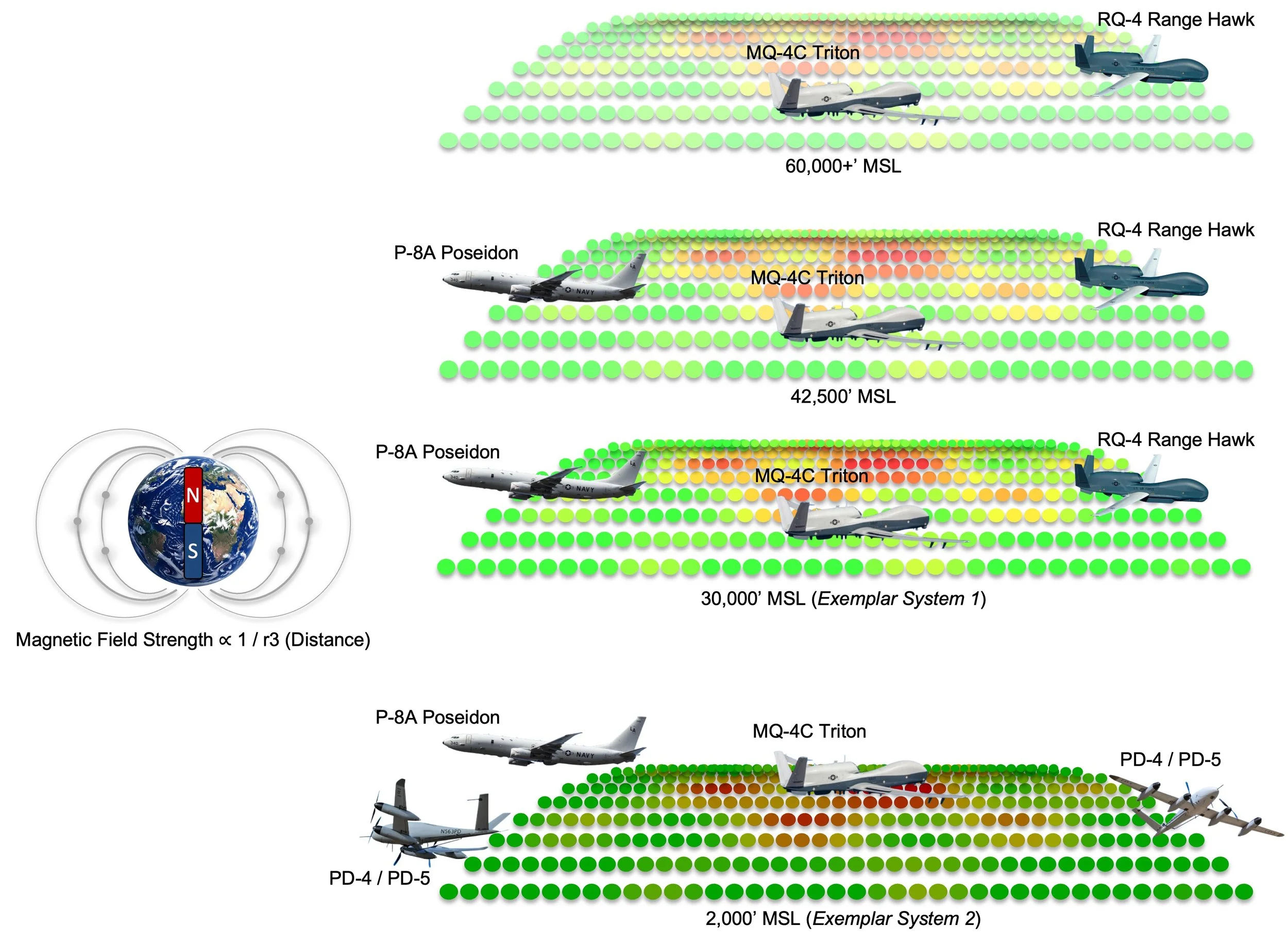
We deliver an aircraft agnostic MagNav payload engineered for rapid integration across operational unmanned and optionally crewed aircraft, minimizing airframe modification and mission system disruption while enabling multi altitude deployment.
To ground the initiative operationally, GMW has modeled existing Southern California coastal range areas for initial reference survey operations and is actively engaging with local maritime range providers to assess progressively larger and more distant survey areas offshore. This phased approach enables the use of maritime ranges tailored to evolving survey mission requirements and supports early acquisition, verification, and validation of airborne magnetic survey results.
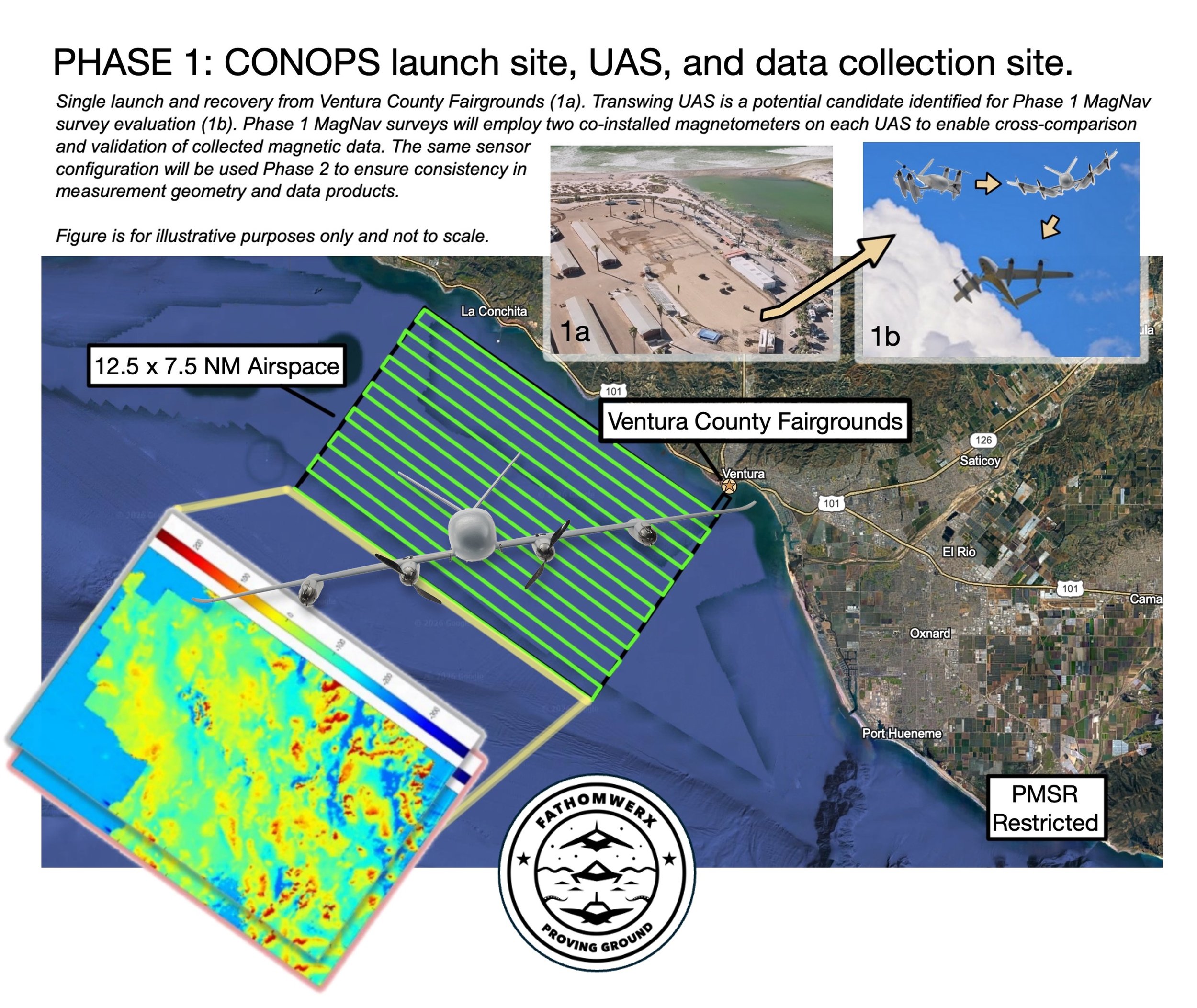
FATHOMWERX Proving Ground will be utilized during Phase I for MagNav payload integration activities and initial survey operations.
The initiative is directly aligned with DIU GAUSS objectives to enable GPS independent navigation pathways and to support resilient navigation for manned, unmanned, and autonomous platforms operating over extended oceanic ranges, contribute to a portfolio approach to resilient PNT, and demonstrate scalable paths from prototype survey operations to repeatable data production.
Further updates will be shared as the effort progresses.
About Global Maritime Werx
Global Maritime Werx is a veteran owned small business focused on empowering information age warfighters by delivering secure, resilient, and mission driven technologies for maritime and over water operations. GMW specializes in maritime domain awareness, secure edge computing, and navigation adjacent systems in support of government and commercial stakeholders.